ChristianStiehl.com

Christian Stiehl.com

Novelist, Graphic Designer, Cartographer, & Illustrator

  • Blog
  • The Novel
  • Old Novel Chapters
  • Drawings

The Ethuveraz: the lands of The Goblin Emperor

February 06, 2024 by Christian Stiehl

A few years ago, I read the wonderful fantasy novel The Goblin Emperor, by Katherine Addison. This is a great book, filled with vivid characters, an intricate plot, and breathtaking world-building. It won the Locus Award for Best Fantasy Novel, and was nominated for the Hugo, Nebula, and World Fantasy awards.

As a fantasy cartographer, one of the things I always look for in a fantasy novel is the map. Unfortunately, there wasn’t one, but I realized that I was in a unique position to change that.

I reached out to the author and offered my services. She shared her original sketches, and over a series of months I produced the map you see above, working closely with her to make sure all the details were right. Serendipitously, she was working on a companion novel set in the same world, The Witness for the Dead. This meant that she was able to direct me to insert details into the map which hadn’t been published in book form yet.

One of the fun things about this particular map was that it offered me the chance to explore an alternate style. Usually, I work in strong ink lines and pay attention to every pixel. This map, by contrast, has softer, looser lines and achieves much of its look through gentle shading. It offers a different feel for the terrain features like mountains, forests, deserts, and swamps. All of the art was drawn in Procreate on the iPad Pro with an Apple Pencil. The text and other graphical elements were built in Adobe Illustrator and Photoshop. With the border, I wanted to evoke a bit of the steampunk feel that bubbles under the surface of the novel—but I had to make sure the teeth of the gears meshed together and each gear was affixed to a hub! There’s nothing sillier than steampunk gears that are just slapped onto surfaces as inoperable ornamentation. Drawing the airships was fun—as readers of the book will know, they’re important to the story.
February 06, 2024 /Christian Stiehl
Comment
Xian Maps Multi Panel.jpg

Multi-panel Maps Sampler

September 21, 2018 by Christian Stiehl

This is just a quick sampler of some of the variety of maps I’ve been working on lately. I’m trying to cover all the bases of a “fantasy cartographer”—with landscape, world, dungeon, isometric buildings, interiors, and city plans…

September 21, 2018 /Christian Stiehl
Comment
The continent-sized map of the mysterious island of Mikscifonia.

The continent-sized map of the mysterious island of Mikscifonia.

Mikscifonia, the Continent

July 16, 2017 by Christian Stiehl

Created as part of a unique challenge at cartographersguild.com, this map is the second part of the double-island that somehow exists simultaneously at both very large and very small sizes. If you match it up against the other Mikscifonia, you'll see that the shape is exactly the same, with only the scale being different. I even created an animated GIF that would smoothly morph between the two.

The unusual compass was part of the challenge, where I was directed to have something other than the standard cardinal directions for this world. Instead, there is a triple compass system involving a "Spinward" direction, a "Windward" direction, and...some other direction beginning with "D" (I'm trying to remember what I had in mind--I drew this a year and a half ago).

Someone asked where I got the icons for the sites, and the answer is that I just drew them. Pixel by pixel. Site location icons are one of the things I'm working on as a cartographer--one of the things I'm trying to get better at doing--and I'm pretty happy with how these came out.

NOTE: I'm also distributing a label-free version of this map that anyone can use for any non-commercial purpose. Fill it with your own place names!

Drawn almost entirely in Procreate on the iPad Pro, using the Apple Pencil. Photoshop was used for the placement of site icons and for textual elements.

July 16, 2017 /Christian Stiehl
Comment
Mikscifonia, the Smaller Island

Mikscifonia, the Smaller Island

A Challenge Map: Mikscifonia, the Smaller Island

July 14, 2017 by Christian Stiehl

This was created as part of a challenge at CartographersGuild.com. The idea was to team up with another cartographer on the site and submit a request to them. The request I got was to create an island that could be many sizes, anywhere from tiny to continent, and have that work (somehow). There was also a mention of unusual directions, I believe--something beyond the normal compass rose. The fancy compass here allows for three simultaneous directions of reckoning, based on three separate phenomena.

I created a pair of maps, one of which you see here, and an animated GIF that would blend the two together. This is the smaller island, while the larger one takes the same shape at a much greater scale.

As with most of my work, this was primarily created on an iPad Pro with the Apple Pencil, in the fantastic app Procreate. I will then normally bring the image into Photoshop to add the textual elements.

July 14, 2017 /Christian Stiehl
2 Comments
Shrine to the Stars Between, a vector-drawn isometric map for fantasy RPGs

Shrine to the Stars Between, a vector-drawn isometric map for fantasy RPGs

Vector Isometric Map: Shrine to the Stars Between

July 12, 2017 by Christian Stiehl

From a couple years ago, this was my first attempt at the "One Page Dungeon" contest. I ran out of time and was unable to finish before the deadline, but I'm still really happy with how much of the map turned out. It's three-level temple, meant to fit into a medieval city block in some fantasy town. The temple is currently boarded up and abandoned, but the adventurers must enter and explore the dangerous and spooky place to rescue children who've gone missing from the local neighborhood. Who is holding them? Are they to be sacrifices to the nameless gods this temple once served? Is the temple secretly being re-occupied?

Obviously, I was heavily inspired by Sutherland's maps for Castle Ravenloft.

NOTE: This map was entirely created in Adobe Illustrator. There was NO 3D RENDERING used. Everything you see is a flat vector shape, drawn, rotated, given a fill of some sort, etc. No actual 3D extruding was used at all. It's the same process I use when freehand-drawing an isometric scene in a paint program like Procreate, except translated to vector shapes in Illustrator: I draw the top-down plan, rotate 45 degrees, then "squish" the plan by 57.77% to get it to isometric view proportions. Then I extrapolate upwards from there. For instance, the staircases are blended shapes that were expanded, run through that isometric process, then manually nudged apart to look three-dimensional.

I also learned about masking vectors with gradient transparency, which was a freaking revelation for an old-school graphic designer like myself, I tell you. We couldn't do that with Illustrator back in the 1990s!

July 12, 2017 /Christian Stiehl
Comment
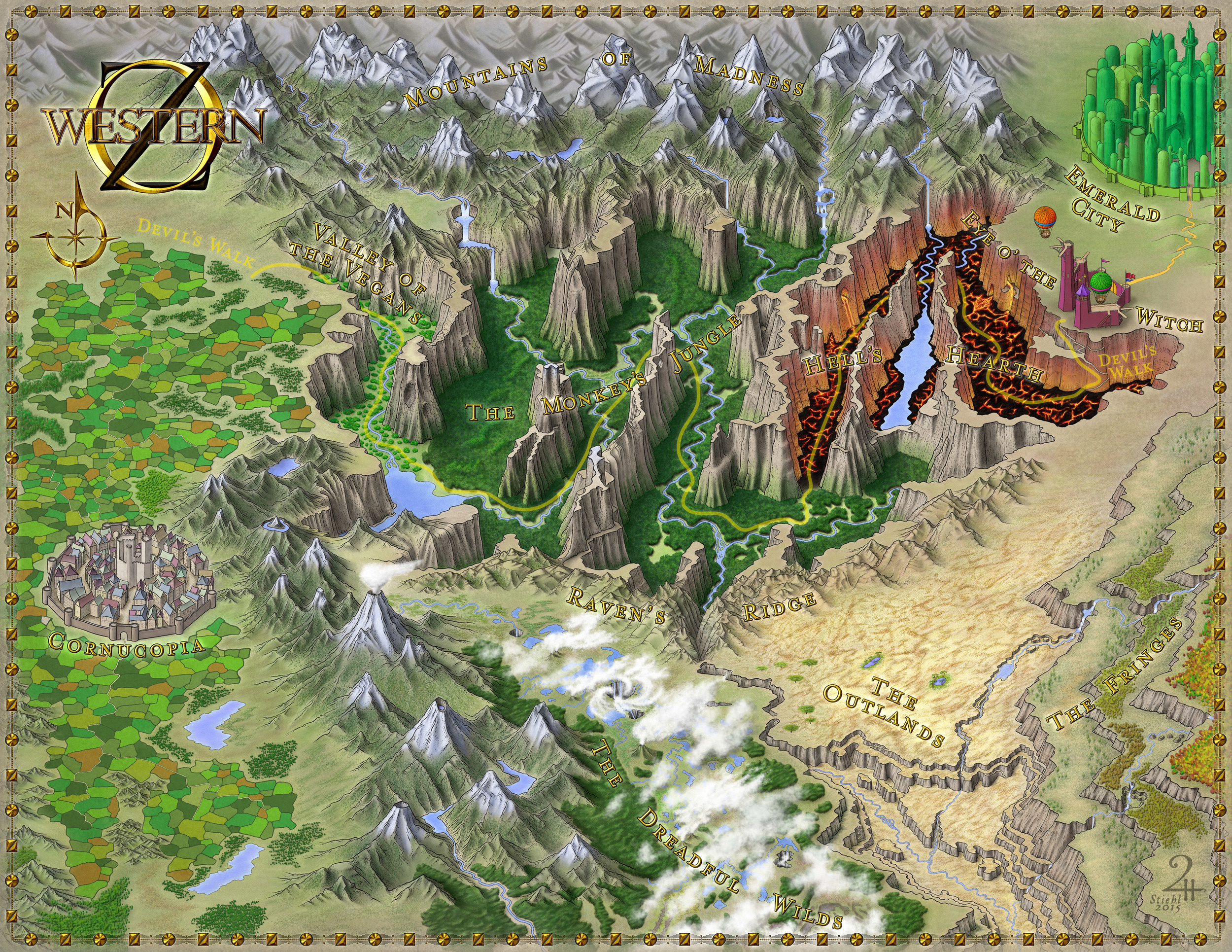
The Lands of Western OZ, depicting primarily No Name Gorge

The Lands of Western OZ, depicting primarily No Name Gorge

Western OZ - Commissioned Map

September 10, 2015 by Christian Stiehl

New stories about Dorothy, Toto, and the wonderful land of OZ are what led to the creation of this map, commissioned by an author for his upcoming book. He has in mind unique and fascinating places not seen before in the published works of L. Frank Baum. This may be why the lands you see in this map won't fit right into any other maps of OZ you might come across. Or perhaps OZ has been changing over the decades. I like to think that the places you see above just slip right in between the existing, canonical regions we know so well.

September 10, 2015 /Christian Stiehl
Comment
  • Newer
  • Older